Split a raster object into a list of smaller rasters based on specified numbers of rows and columns. It can optionally save the resulting rasters to disk, plot them, or return just their extents.
Usage
SplitRaster(
  raster = NULL,
  Ncol = 4,
  Nrow = 4,
  save = FALSE,
  SplitPath = "",
  plot = FALSE,
  Extent = FALSE
)
Arguments
- raster
A raster object to be split. If NULL (the default), the function will not execute.
- Ncol, Nrow
Integer. The desired number of columns and rows to split the raster into. Default is 4 columns and 4 rows.
- save
Logical. Whether to save the split rasters to disk. Default is
FALSE.- SplitPath
Character. Directory path where the split rasters should be saved if
saveisTRUE. If the directory does not exist, it will be created.- plot
Logical. Whether to plot the split rasters. Default is
FALSE.- Extent
Logical. If
TRUE, the function returns only the extents of the split rasters instead of the raster data. Default isFALSE.
Value
A list of raster objects or extents of the split rasters, depending
on the value of the Extent parameter.
Examples
library(raster)
logo <- raster(system.file("external/rlogo.grd", package = "raster"))
plot(logo, axes = FALSE, legend = FALSE, bty = "n",
box = FALSE, main = "Original raster layer")
 # --------------------------------------------------
# Split into 3 rows and 3 columns
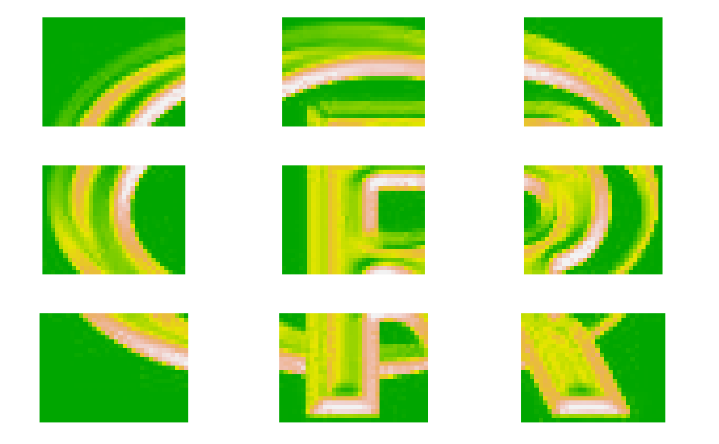
logoSplit <- SplitRaster(raster = logo, Ncol = 3, Nrow = 3, plot = TRUE)
# --------------------------------------------------
# Split into 3 rows and 3 columns
logoSplit <- SplitRaster(raster = logo, Ncol = 3, Nrow = 3, plot = TRUE)
 print(logoSplit) # a list object of 9 items
#> [[1]]
#> class : RasterLayer
#> dimensions : 26, 34, 884 (nrow, ncol, ncell)
#> resolution : 1, 1 (x, y)
#> extent : 0, 34, 51, 77 (xmin, xmax, ymin, ymax)
#> crs : +proj=merc +lon_0=0 +k=1 +x_0=0 +y_0=0 +datum=WGS84 +units=m +no_defs
#> source : memory
#> names : red
#> values : 0, 255 (min, max)
#>
#>
#> [[2]]
#> class : RasterLayer
#> dimensions : 26, 34, 884 (nrow, ncol, ncell)
#> resolution : 1, 1 (x, y)
#> extent : 34, 68, 51, 77 (xmin, xmax, ymin, ymax)
#> crs : +proj=merc +lon_0=0 +k=1 +x_0=0 +y_0=0 +datum=WGS84 +units=m +no_defs
#> source : memory
#> names : red
#> values : 0, 255 (min, max)
#>
#>
#> [[3]]
#> class : RasterLayer
#> dimensions : 26, 33, 858 (nrow, ncol, ncell)
#> resolution : 1, 1 (x, y)
#> extent : 68, 101, 51, 77 (xmin, xmax, ymin, ymax)
#> crs : +proj=merc +lon_0=0 +k=1 +x_0=0 +y_0=0 +datum=WGS84 +units=m +no_defs
#> source : memory
#> names : red
#> values : 32, 255 (min, max)
#>
#>
#> [[4]]
#> class : RasterLayer
#> dimensions : 26, 34, 884 (nrow, ncol, ncell)
#> resolution : 1, 1 (x, y)
#> extent : 0, 34, 25, 51 (xmin, xmax, ymin, ymax)
#> crs : +proj=merc +lon_0=0 +k=1 +x_0=0 +y_0=0 +datum=WGS84 +units=m +no_defs
#> source : memory
#> names : red
#> values : 0, 255 (min, max)
#>
#>
#> [[5]]
#> class : RasterLayer
#> dimensions : 26, 34, 884 (nrow, ncol, ncell)
#> resolution : 1, 1 (x, y)
#> extent : 34, 68, 25, 51 (xmin, xmax, ymin, ymax)
#> crs : +proj=merc +lon_0=0 +k=1 +x_0=0 +y_0=0 +datum=WGS84 +units=m +no_defs
#> source : memory
#> names : red
#> values : 0, 255 (min, max)
#>
#>
#> [[6]]
#> class : RasterLayer
#> dimensions : 26, 33, 858 (nrow, ncol, ncell)
#> resolution : 1, 1 (x, y)
#> extent : 68, 101, 25, 51 (xmin, xmax, ymin, ymax)
#> crs : +proj=merc +lon_0=0 +k=1 +x_0=0 +y_0=0 +datum=WGS84 +units=m +no_defs
#> source : memory
#> names : red
#> values : 0, 255 (min, max)
#>
#>
#> [[7]]
#> class : RasterLayer
#> dimensions : 25, 34, 850 (nrow, ncol, ncell)
#> resolution : 1, 1 (x, y)
#> extent : 0, 34, 0, 25 (xmin, xmax, ymin, ymax)
#> crs : +proj=merc +lon_0=0 +k=1 +x_0=0 +y_0=0 +datum=WGS84 +units=m +no_defs
#> source : memory
#> names : red
#> values : 37, 255 (min, max)
#>
#>
#> [[8]]
#> class : RasterLayer
#> dimensions : 25, 34, 850 (nrow, ncol, ncell)
#> resolution : 1, 1 (x, y)
#> extent : 34, 68, 0, 25 (xmin, xmax, ymin, ymax)
#> crs : +proj=merc +lon_0=0 +k=1 +x_0=0 +y_0=0 +datum=WGS84 +units=m +no_defs
#> source : memory
#> names : red
#> values : 0, 255 (min, max)
#>
#>
#> [[9]]
#> class : RasterLayer
#> dimensions : 25, 33, 825 (nrow, ncol, ncell)
#> resolution : 1, 1 (x, y)
#> extent : 68, 101, 0, 25 (xmin, xmax, ymin, ymax)
#> crs : +proj=merc +lon_0=0 +k=1 +x_0=0 +y_0=0 +datum=WGS84 +units=m +no_defs
#> source : memory
#> names : red
#> values : 0, 255 (min, max)
#>
#>
# --------------------------------------------------
# Merging split maps again
logoSplit$fun <- mean
logoSplit$na.rm <- TRUE
logoSplit2 <- do.call(mosaic, logoSplit)
par(mfrow = c(1, 1))
plot(logoSplit2, axes = FALSE, legend = FALSE, bty = "n",
box = FALSE, main = "Merged raster layers")
print(logoSplit) # a list object of 9 items
#> [[1]]
#> class : RasterLayer
#> dimensions : 26, 34, 884 (nrow, ncol, ncell)
#> resolution : 1, 1 (x, y)
#> extent : 0, 34, 51, 77 (xmin, xmax, ymin, ymax)
#> crs : +proj=merc +lon_0=0 +k=1 +x_0=0 +y_0=0 +datum=WGS84 +units=m +no_defs
#> source : memory
#> names : red
#> values : 0, 255 (min, max)
#>
#>
#> [[2]]
#> class : RasterLayer
#> dimensions : 26, 34, 884 (nrow, ncol, ncell)
#> resolution : 1, 1 (x, y)
#> extent : 34, 68, 51, 77 (xmin, xmax, ymin, ymax)
#> crs : +proj=merc +lon_0=0 +k=1 +x_0=0 +y_0=0 +datum=WGS84 +units=m +no_defs
#> source : memory
#> names : red
#> values : 0, 255 (min, max)
#>
#>
#> [[3]]
#> class : RasterLayer
#> dimensions : 26, 33, 858 (nrow, ncol, ncell)
#> resolution : 1, 1 (x, y)
#> extent : 68, 101, 51, 77 (xmin, xmax, ymin, ymax)
#> crs : +proj=merc +lon_0=0 +k=1 +x_0=0 +y_0=0 +datum=WGS84 +units=m +no_defs
#> source : memory
#> names : red
#> values : 32, 255 (min, max)
#>
#>
#> [[4]]
#> class : RasterLayer
#> dimensions : 26, 34, 884 (nrow, ncol, ncell)
#> resolution : 1, 1 (x, y)
#> extent : 0, 34, 25, 51 (xmin, xmax, ymin, ymax)
#> crs : +proj=merc +lon_0=0 +k=1 +x_0=0 +y_0=0 +datum=WGS84 +units=m +no_defs
#> source : memory
#> names : red
#> values : 0, 255 (min, max)
#>
#>
#> [[5]]
#> class : RasterLayer
#> dimensions : 26, 34, 884 (nrow, ncol, ncell)
#> resolution : 1, 1 (x, y)
#> extent : 34, 68, 25, 51 (xmin, xmax, ymin, ymax)
#> crs : +proj=merc +lon_0=0 +k=1 +x_0=0 +y_0=0 +datum=WGS84 +units=m +no_defs
#> source : memory
#> names : red
#> values : 0, 255 (min, max)
#>
#>
#> [[6]]
#> class : RasterLayer
#> dimensions : 26, 33, 858 (nrow, ncol, ncell)
#> resolution : 1, 1 (x, y)
#> extent : 68, 101, 25, 51 (xmin, xmax, ymin, ymax)
#> crs : +proj=merc +lon_0=0 +k=1 +x_0=0 +y_0=0 +datum=WGS84 +units=m +no_defs
#> source : memory
#> names : red
#> values : 0, 255 (min, max)
#>
#>
#> [[7]]
#> class : RasterLayer
#> dimensions : 25, 34, 850 (nrow, ncol, ncell)
#> resolution : 1, 1 (x, y)
#> extent : 0, 34, 0, 25 (xmin, xmax, ymin, ymax)
#> crs : +proj=merc +lon_0=0 +k=1 +x_0=0 +y_0=0 +datum=WGS84 +units=m +no_defs
#> source : memory
#> names : red
#> values : 37, 255 (min, max)
#>
#>
#> [[8]]
#> class : RasterLayer
#> dimensions : 25, 34, 850 (nrow, ncol, ncell)
#> resolution : 1, 1 (x, y)
#> extent : 34, 68, 0, 25 (xmin, xmax, ymin, ymax)
#> crs : +proj=merc +lon_0=0 +k=1 +x_0=0 +y_0=0 +datum=WGS84 +units=m +no_defs
#> source : memory
#> names : red
#> values : 0, 255 (min, max)
#>
#>
#> [[9]]
#> class : RasterLayer
#> dimensions : 25, 33, 825 (nrow, ncol, ncell)
#> resolution : 1, 1 (x, y)
#> extent : 68, 101, 0, 25 (xmin, xmax, ymin, ymax)
#> crs : +proj=merc +lon_0=0 +k=1 +x_0=0 +y_0=0 +datum=WGS84 +units=m +no_defs
#> source : memory
#> names : red
#> values : 0, 255 (min, max)
#>
#>
# --------------------------------------------------
# Merging split maps again
logoSplit$fun <- mean
logoSplit$na.rm <- TRUE
logoSplit2 <- do.call(mosaic, logoSplit)
par(mfrow = c(1, 1))
plot(logoSplit2, axes = FALSE, legend = FALSE, bty = "n",
box = FALSE, main = "Merged raster layers")
 print({logoSplit2 - logo}) # No value difference!
#> class : RasterLayer
#> dimensions : 77, 101, 7777 (nrow, ncol, ncell)
#> resolution : 1, 1 (x, y)
#> extent : 0, 101, 0, 77 (xmin, xmax, ymin, ymax)
#> crs : +proj=merc +lon_0=0 +k=1 +x_0=0 +y_0=0 +datum=WGS84 +units=m +no_defs
#> source : memory
#> names : layer
#> values : 0, 0 (min, max)
#>
# --------------------------------------------------
logoSplit <- SplitRaster(logo, Ncol = 3, Nrow = 3, Extent = TRUE)
print(logoSplit)
#> [[1]]
#> class : Extent
#> xmin : 0
#> xmax : 34
#> ymin : 51
#> ymax : 77
#>
#> [[2]]
#> class : Extent
#> xmin : 34
#> xmax : 68
#> ymin : 51
#> ymax : 77
#>
#> [[3]]
#> class : Extent
#> xmin : 68
#> xmax : 102
#> ymin : 51
#> ymax : 77
#>
#> [[4]]
#> class : Extent
#> xmin : 0
#> xmax : 34
#> ymin : 25
#> ymax : 51
#>
#> [[5]]
#> class : Extent
#> xmin : 34
#> xmax : 68
#> ymin : 25
#> ymax : 51
#>
#> [[6]]
#> class : Extent
#> xmin : 68
#> xmax : 102
#> ymin : 25
#> ymax : 51
#>
#> [[7]]
#> class : Extent
#> xmin : 0
#> xmax : 34
#> ymin : -1
#> ymax : 25
#>
#> [[8]]
#> class : Extent
#> xmin : 34
#> xmax : 68
#> ymin : -1
#> ymax : 25
#>
#> [[9]]
#> class : Extent
#> xmin : 68
#> xmax : 102
#> ymin : -1
#> ymax : 25
#>
print({logoSplit2 - logo}) # No value difference!
#> class : RasterLayer
#> dimensions : 77, 101, 7777 (nrow, ncol, ncell)
#> resolution : 1, 1 (x, y)
#> extent : 0, 101, 0, 77 (xmin, xmax, ymin, ymax)
#> crs : +proj=merc +lon_0=0 +k=1 +x_0=0 +y_0=0 +datum=WGS84 +units=m +no_defs
#> source : memory
#> names : layer
#> values : 0, 0 (min, max)
#>
# --------------------------------------------------
logoSplit <- SplitRaster(logo, Ncol = 3, Nrow = 3, Extent = TRUE)
print(logoSplit)
#> [[1]]
#> class : Extent
#> xmin : 0
#> xmax : 34
#> ymin : 51
#> ymax : 77
#>
#> [[2]]
#> class : Extent
#> xmin : 34
#> xmax : 68
#> ymin : 51
#> ymax : 77
#>
#> [[3]]
#> class : Extent
#> xmin : 68
#> xmax : 102
#> ymin : 51
#> ymax : 77
#>
#> [[4]]
#> class : Extent
#> xmin : 0
#> xmax : 34
#> ymin : 25
#> ymax : 51
#>
#> [[5]]
#> class : Extent
#> xmin : 34
#> xmax : 68
#> ymin : 25
#> ymax : 51
#>
#> [[6]]
#> class : Extent
#> xmin : 68
#> xmax : 102
#> ymin : 25
#> ymax : 51
#>
#> [[7]]
#> class : Extent
#> xmin : 0
#> xmax : 34
#> ymin : -1
#> ymax : 25
#>
#> [[8]]
#> class : Extent
#> xmin : 34
#> xmax : 68
#> ymin : -1
#> ymax : 25
#>
#> [[9]]
#> class : Extent
#> xmin : 68
#> xmax : 102
#> ymin : -1
#> ymax : 25
#>